Michigan Upper Peninsula: The Complete First-Timer’s Guide to the UP (2026)
Last Updated: May 2026
The Michigan Upper Peninsula covers 16,000 square miles — larger than nine U.S. states — with 400 miles of Great Lakes shoreline and stretches of road where you can drive 45 minutes without seeing another car. Most first-time visitors plan a long weekend, drive to Tahquamenon Falls, take a photo, and turn around. They’ve technically been to the UP. They’ve seen approximately 20% of it.
I’ve covered Michigan travel for more than a decade for outlets including The Washington Post, WDIV Detroit, FOX 32 Chicago, FOX 17 West Michigan, and FOX 2 Detroit — and I’ve been crossing the Mackinac Bridge to the UP since I was a kid. This isn’t a destination roundup. It’s the planning framework I wish someone had given me before my first real UP trip: how to think about the region, how long you actually need, which mistakes first-timers make, what to skip if you only have a long weekend, where to eat, when to go.
📌 Planning a Michigan Upper Peninsula Trip: In a Nutshell
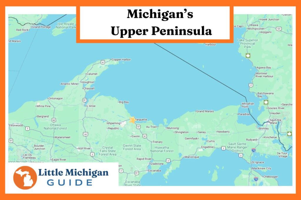
- The Michigan Upper Peninsula breaks into 5 planning regions: Eastern UP (St. Ignace, Sault Ste. Marie, Tahquamenon), the Pictured Rocks corridor (Munising), Marquette and the central UP, the Keweenaw Peninsula, and the Porcupine Mountains.
- Minimum trip length: 4 days for the Eastern UP alone. 7 days for a full peninsula loop. 10 days to do it without rushing.
- Only one road in: the Mackinac Bridge — 5 miles, $4.00 cash, $4.10 by credit card (2.3% convenience fee since January 2025, no American Express).
- Best season for first-timers: Late June through early October. September is the underrated peak — fewer crowds, most tours still running, fall color beginning.
- Book Pictured Rocks boat cruises and kayak tours at least 2–3 weeks ahead for peak July and August weekends.
- Cell service disappears across large stretches. Download offline maps before you cross the bridge.
- Eat a pasty. Pronounced PASS-tee, not PAY-stee.
Why Now / What’s New for 2026
- Mackinac Bridge toll: $4.00 cash, $4.10 credit (2.3% convenience fee in effect since January 2025; American Express no longer accepted).
- MacPass commuter accounts: Initial deposit lowered to $40, refills $20 (down from $80/$50). Worth it if you’ll cross more than twice.
- Pictured Rocks tour availability: Operators have expanded 2026 schedules, but peak July/August weekends still sell out 2–3 weeks ahead.
- Annual Mackinac Bridge Walk: Labor Day Monday — the one day each year vehicles can’t cross. Plan around it if you’re traveling Labor Day weekend.
How to Think About the Michigan Upper Peninsula
The Michigan Upper Peninsula is not a single destination. It is a region the size of New Hampshire and Vermont combined, with five distinct sub-regions that each function as their own trip. Understanding those five regions is the planning unlock — once you know them, you can build a realistic itinerary in about ten minutes.
First-timers almost always make the same planning mistake: they treat the UP as one place. Then they look at a map, see that Copper Harbor is 6 hours from St. Ignace, and either compress their itinerary into a death-march road trip or skip 80% of the peninsula. The five-region framework prevents both outcomes.
Region 1: The Eastern UP. You cross the Mackinac Bridge into St. Ignace and you’re here. This is the most accessible part of the UP for anyone driving from southern Michigan or Chicago — Tahquamenon Falls, Sault Ste. Marie and the Soo Locks, ferries to Mackinac Island, and your first pasty shop. A 3-day weekend can cover the highlights. Most first-timers stop here and call it a UP trip. They’re missing 80% of the peninsula.
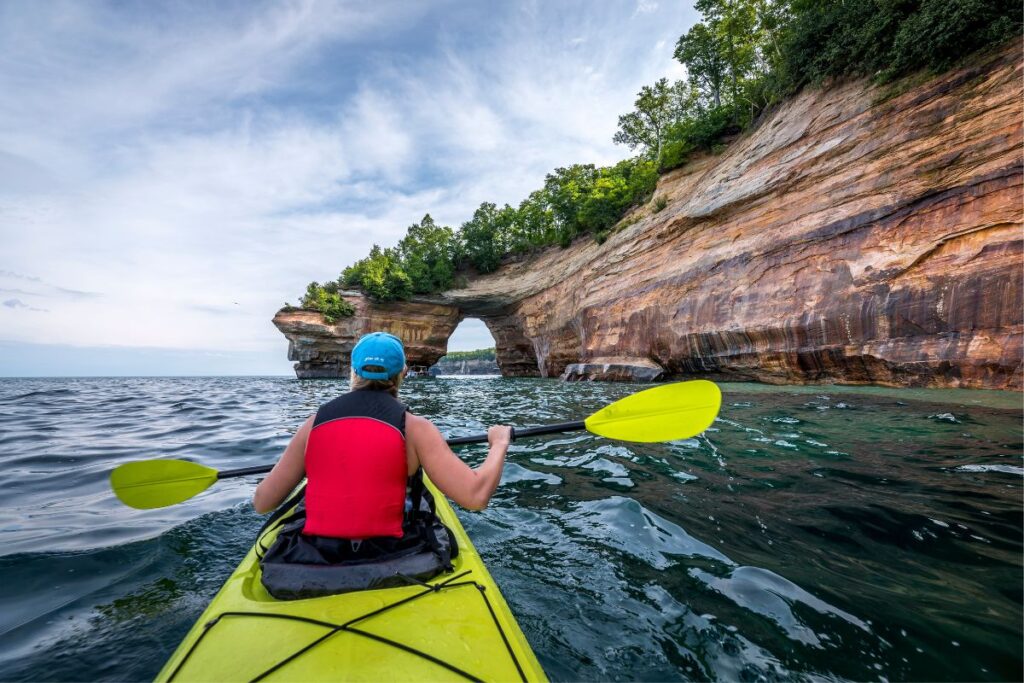
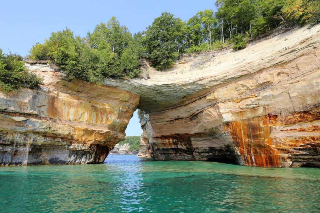
Region 2: The Pictured Rocks Corridor. Munising and the 42 miles of Lake Superior shoreline that make up Pictured Rocks National Lakeshore. The single most photographed stretch of the UP — sandstone cliffs up to 200 feet tall, sea caves, and Lake Superior water that looks Caribbean in the right light. Plan a minimum of 2 full days here, ideally 3. Book your boat cruise or kayak tour the moment you set your dates.
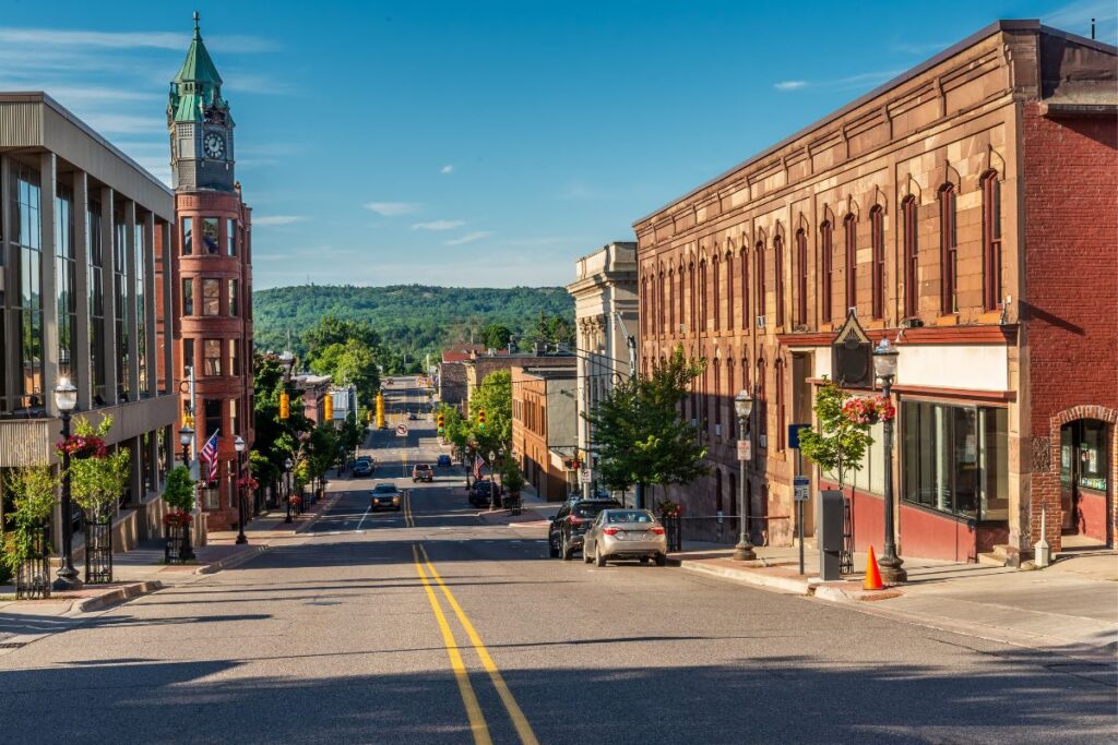
Marquette is the UP’s only city of size and the right overnight anchor for the central UP.
Region 3: Marquette and the Central UP. The UP’s only real city (population 20,000), home to Northern Michigan University, a walkable waterfront, the best restaurants in the peninsula, and the Iron Ore Heritage Trail along Lake Superior. This is where you re-civilize after a few days of state parks and pasty shops. Marquette is the right overnight anchor for anyone exploring the central UP, and the right break point between Pictured Rocks and the Keweenaw.
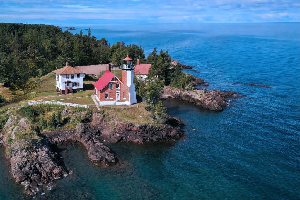
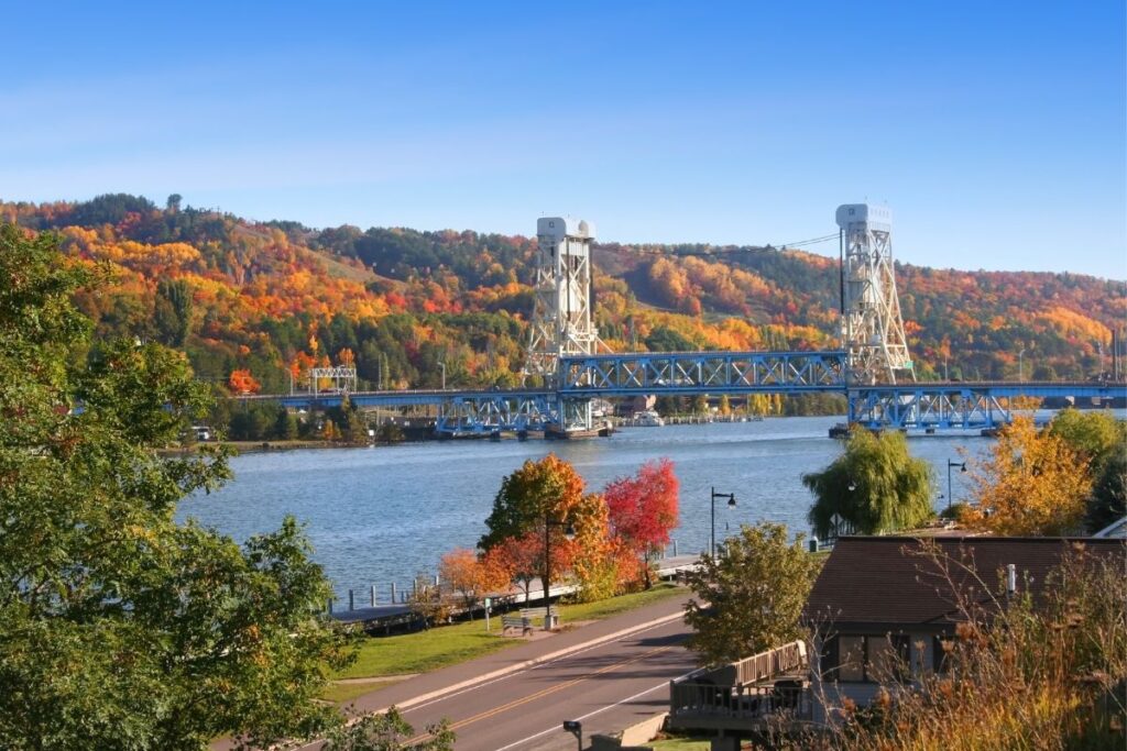
Region 4: The Keweenaw Peninsula. The finger of land that juts northeast from the western UP into Lake Superior — and the most historically interesting part of the entire region. From 1840 to 1968, the Keweenaw produced more copper than any place on earth. The towns left behind (Calumet, Hancock, Houghton, Laurium, Copper Harbor) are intact 19th-century industrial heritage at a scale you won’t find anywhere else in the Midwest. Allow 2 full days minimum. Copper Harbor at the tip is one of the most remote and most loved small towns in Michigan.
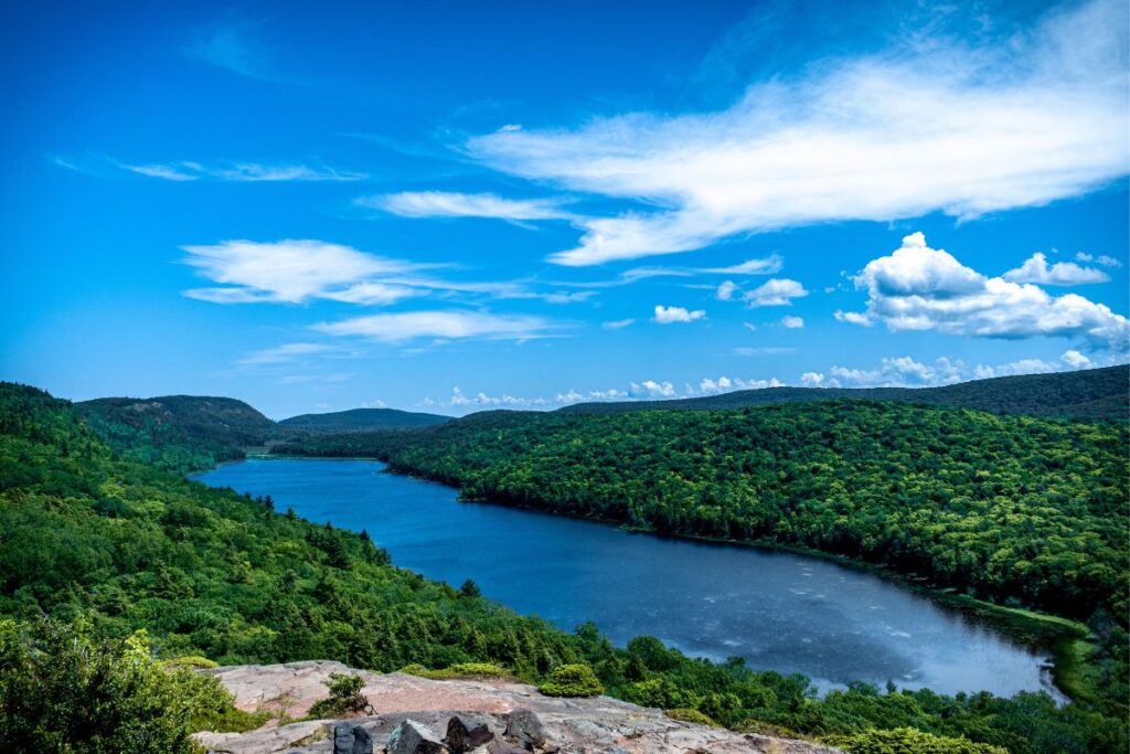
Region 5: The Porcupine Mountains. The western UP wilderness — 59,000 acres of state park, the largest remaining tract of old-growth northern hardwood forest east of the Mississippi, and the famously photogenic Lake of the Clouds overlook. This is the most genuinely wild part of the UP. Black bears are common, moose sightings happen, and the interior backcountry sees almost no day visitors. Allow at least one full day for the highlights, more for the backcountry.
Field Note: The single best decision a first-timer can make is to pick three of these five regions, not all five. Trying to cover all five in 7 days means seven hours a day in the car and 90 minutes at each stop. Pick three, do them well, and come back for the others next year. The UP rewards return visits in a way most travel destinations don’t.

How Long Do You Actually Need for the Upper Peninsula?
The honest framework, after years of doing every version of this trip, looks like this:
| Time | What to Cover | What to Skip |
|---|---|---|
| Long weekend (3 days) | Eastern UP only — Mackinac Bridge, Tahquamenon Falls, Sault Ste. Marie. Stay in Paradise or Sault. | Everything west of Newberry. The UP is too big for a long weekend. |
| 4–5 days | Eastern UP plus the Pictured Rocks corridor. Add Munising and 2 days at the National Lakeshore. | Marquette, the Keweenaw, the Porkies. They need a return trip. |
| 7 days | Bridge → Tahquamenon → Pictured Rocks → Marquette → Keweenaw → Porkies → home via US-2. The classic UP loop. | Backcountry hiking, multi-day kayak trips, Isle Royale. Those are separate trips. |
| 10 days | Everything above plus the Isle Royale ferry from Copper Harbor, Porkies backcountry cabins, and a slower pace throughout. | Nothing. This is the version that lets the UP breathe. |
The biggest first-timer mistake is trying to do a 7-day trip in 4 days. Don’t. If you only have 4 days, the right move is to cover the Eastern UP and Pictured Rocks well, then plan a second trip for the Keweenaw and Porkies. Trying to squeeze all five regions into a long weekend means you spend the trip in the car and remember almost none of it.
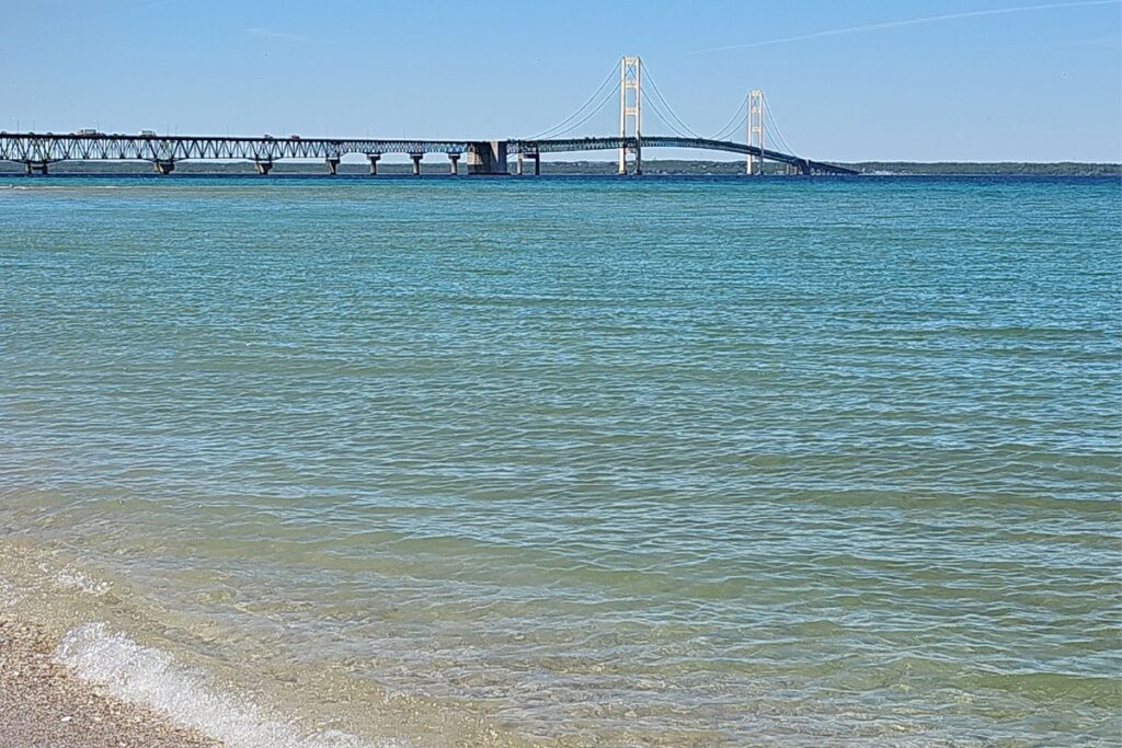
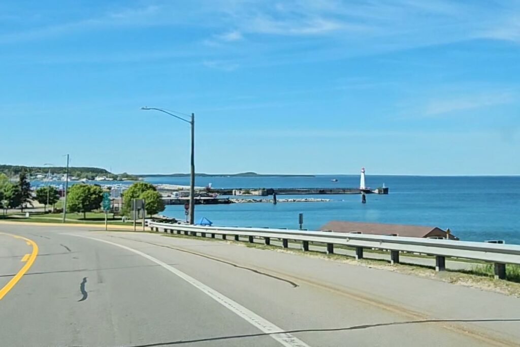
The 5-mile Mackinac Bridge connects Mackinaw City to St. Ignace and is the only road into the UP.
Getting to the Upper Peninsula: The Bridge Is the Only Road
There is one road into the Michigan Upper Peninsula: the Mackinac Bridge. Every car, truck, and RV crosses this 5-mile suspension bridge at the Straits of Mackinac, where Lake Michigan meets Lake Huron. The bridge has stood since 1957 and has no alternative. You pay the toll, you drive across, and the UP begins in St. Ignace on the other side.
Drive times to St. Ignace, the eastern UP entry point: about 4 hours from Detroit (290 miles on I-75), 3.5 hours from Grand Rapids (230 miles), 3 hours from Lansing, 5.5 hours from Chicago (370 miles), and 2.5 hours from Traverse City.
There is no passenger rail service to the UP. Sawyer International Airport in Marquette (MQT) is the region’s primary commercial airport with service to Detroit and Chicago; Pellston Regional (PLN) serves the Mackinaw City and St. Ignace gateway. But the drive is part of the experience — and the moment you crest the bridge and see the UP open up in front of you is one most people remember for years.
The bridge itself is worth pausing on. The roadway sits 200 feet above the water, and the outer lanes are open steel grating — you can see the water below through the road surface. If that unnerves you, the Mackinac Bridge Authority’s Driver Assistance Program will send a staff member to drive your vehicle across for $10 plus the toll. The service runs 24 hours a day, 7 days a week. Call (906) 643-7600 in advance, or request it at the toll booth. About 1,000 people use it every year.
On Labor Day Monday, the bridge closes to vehicles for the annual Bridge Walk, when tens of thousands of people walk across on foot. If you’re planning Labor Day weekend travel, plan around that closure.
📍 Mackinac Bridge — Quick Facts
- Toll: $4.00 cash · $4.10 credit (2.3% convenience fee) · No American Express
- Speed limit: 45 mph on the bridge
- Driver Assistance Program: $10 plus toll · Call (906) 643-7600 · Available 24/7
- Length: 5 miles · Open 24/7/365 except Labor Day morning
- Closure: Annual Bridge Walk, Labor Day Monday (6:30 AM–noon)
- Official: mackinacbridge.org
What First-Timers Skip in the Upper Peninsula — And Shouldn’t
Most first Michigan Upper Peninsula trips follow the same pattern: bridge, Tahquamenon, photo, home. The four things below get missed most often — and each is worth building into even a short trip.
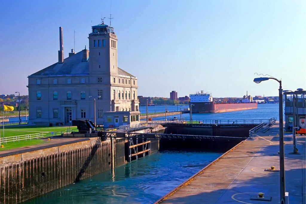
More tonnage passes through the Soo Locks annually than the Panama and Suez canals combined.
The Soo Locks in Sault Ste. Marie. A series of locks that lift and lower 1,000-foot freighters 21 feet to navigate the elevation difference between Lake Superior and the lower Great Lakes. More tonnage passes through annually than the Panama and Suez canals combined. Watching a freighter lock through — close enough to see the crew on deck — is genuinely awe-inspiring, and the US Army Corps of Engineers observation deck is free. An hour out of your way from Tahquamenon. Worth it.
The Marquette waterfront. Most UP itineraries treat Marquette as a refueling stop between regions. It is actually a destination — a walkable college-town downtown with the best restaurants in the peninsula, an Iron Ore Heritage Trail along the waterfront, Presque Isle Park (a 323-acre forested peninsula that juts into Lake Superior), and working iron ore docks where you can watch 700-foot ore boats load. Spend a full day. You’ll appreciate it more than you expect.
The Keweenaw drive. US-41 north from Houghton through Calumet, Laurium, and Mohawk to Copper Harbor at the tip is one of the great American small-town drives. The towns are intact 19th-century copper-boom communities — Calumet alone has more historic architecture than most cities ten times its size. The drive takes 2 hours one way without stops. Allow 6 with stops.
Lake of the Clouds at golden hour. Most visitors stop at the Porcupine Mountains overlook midday, take a quick photo, and leave. The view is dramatically better an hour before sunset — light hits the old-growth forest at an angle that makes the lake look like a different place. If you’re staying in Ontonagon, drive out for the evening.
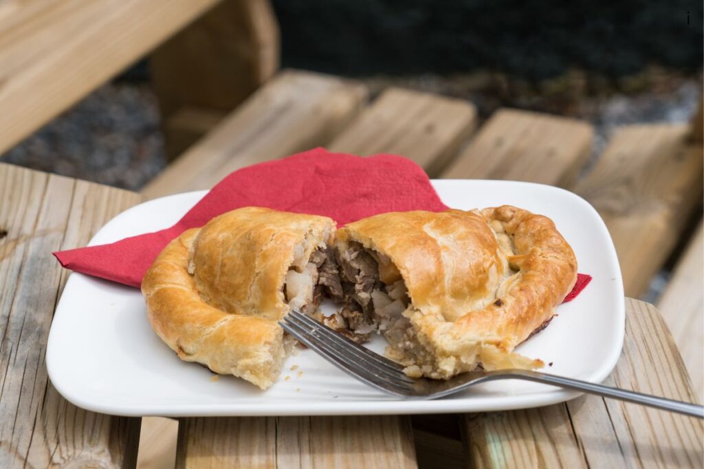
Why You Have to Eat a Pasty in the UP — And Where
The pasty (pronounced “PASS-tee” — getting this wrong is one of the fastest ways to identify yourself as a first-timer) is the defining food of the Michigan Upper Peninsula. A hand-held meat-and-vegetable pie with a thick crimped crust, it was brought to the Keweenaw by Cornish copper miners in the 1840s and adopted by Finnish, Italian, and Croatian immigrant mining communities until it became the food of the entire region.
The traditional filling is beef, potato, rutabaga, and onion. The crust is dense and crimped because Cornish miners carried them into the shafts for lunch — the crust kept the filling warm for hours and gave miners a handle so they could eat without washing their hands.
Every UP town of any size has a pasty shop, and the debate over whose is best is essentially the UP’s version of Chicago’s deep-dish debate — passionate, regional, and unresolvable. The ketchup-versus-gravy question is equally contentious (traditional is ketchup; gravy is acceptable). I stop at whichever shop is closest on the day — the regional variation in spicing and crust thickness is real and worth tasting your way through.
If you want anchor recommendations: Lehto’s Pasties on US-2 in St. Ignace is the eastern UP’s most famous shop and a logical first stop after crossing the bridge. Jean Kay’s in Marquette is a long-running local institution. The Keweenaw towns (Houghton, Hancock, Calumet) have the highest concentration of quality pasty shops — this is the historical heartland of the pasty, and the bakeries here treat it with the seriousness it deserves.
When to Visit the Michigan Upper Peninsula (And Why September Is the Smart Pick)
Late June through August is the obvious window — warmest temperatures, full tour access, all attractions open, longest daylight. It is also the most crowded and most expensive time to be in the UP. Pictured Rocks tours sell out weeks ahead. Munising lodging hits peak rates. The roads have other people on them.
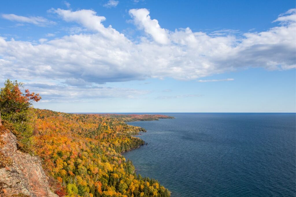
The smarter pick for first-timers who can swing it: September. Tower climbs, boat tours, and kayak operators are still running through mid-month. Daytime temperatures sit in the 60s. Crowds drop sharply after Labor Day. And the UP’s fall color, which peaks roughly late September through mid-October depending on the year, is one of the most spectacular displays in the country. The light is also dramatically better — September sun hits the Pictured Rocks cliffs at an angle that makes the mineral staining glow in a way midsummer light flattens out.
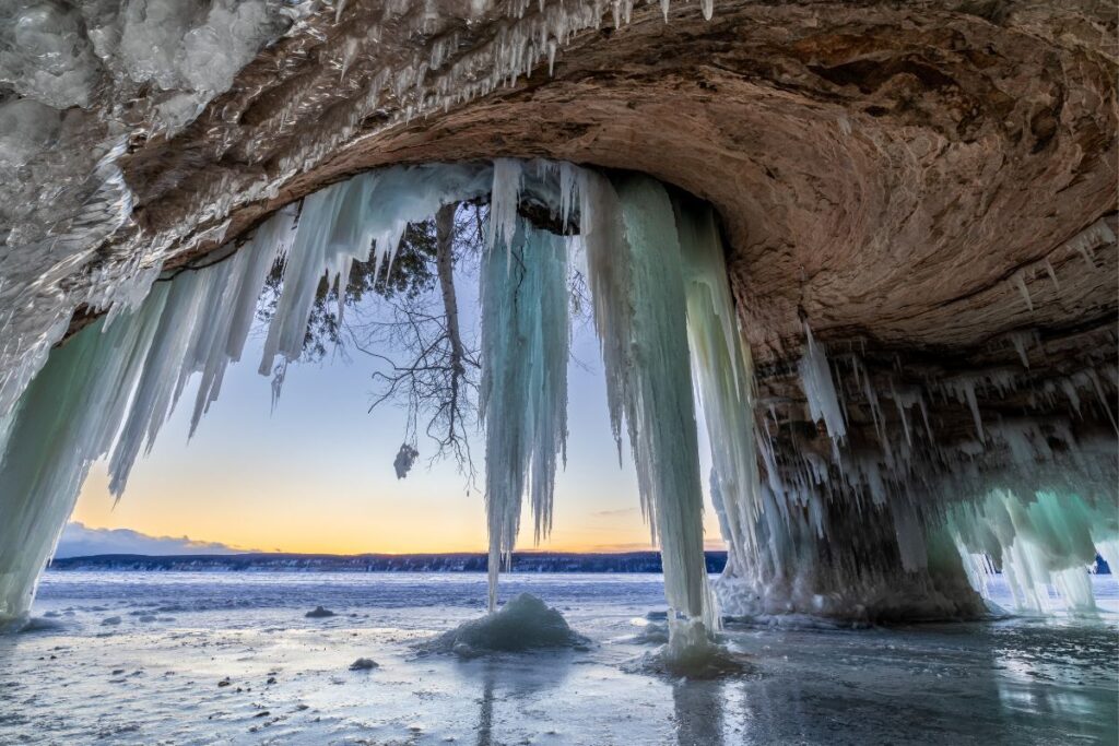
Winter is a different trip entirely. The Pictured Rocks ice caves — formed when the sea caves freeze over, typically February — are one of the most extraordinary natural formations in the Midwest. The Keweenaw gets 200 to 300-plus inches of snow annually and offers world-class snowmobiling and cross-country skiing. But winter requires real cold-weather preparation, careful route planning around snowmobile-only roads, and a tolerance for genuine isolation. Save winter for your second UP trip, not your first.
Late spring (May through early June) has mud season and serious black flies — locals don’t recommend it for first-timers. The waterfalls are at peak flow, which is a draw if you’re a photographer, but the bugs are real and some seasonal businesses haven’t opened yet.
Practical Logistics Most Upper Peninsula First-Timers Get Wrong
The Michigan Upper Peninsula punishes unprepared travelers more than most American destinations. Not dramatically — you are not going to get lost in the wilderness — but enough that small oversights compound across a week.
Cell service disappears. Entire stretches of US-2 and M-28 have zero service for 30–60 miles. The Keweenaw north of Houghton, the Porkies interior, and the central UP between Munising and Marquette are dead zones. Download offline maps in Google Maps before you cross the bridge — open the app, search “Upper Peninsula Michigan,” tap the map name, and select Download. Do the same in Maps.me as a backup. A paper map of the UP is genuinely useful, too.
Gas station gaps. Some stretches go 50–70 miles between stations. The M-28 corridor west of Marquette and US-41 north of Houghton are the trouble spots. Fill up in Marquette, Houghton, and Ontonagon before heading into the backcountry sections. Top off whenever you see a pump, not when you’re at half a tank.
Lodging books up months ahead. Munising, Copper Harbor, and the Porcupine Mountains have limited lodging, and peak season disappears in February for the following summer. Marquette has more options but also fills up on summer weekends. Book the same day you set your dates. Vacation rentals on the UP coast often require 3–7 night minimum stays in summer.
Lake Superior is cold. Even in August, surface temperatures rarely exceed 60°F and often sit at 50–55°F. Swimming is possible — locals do it — but the cold-shock effect is real. Kayak outfitters provide drysuits or wetsuits for a reason. If you want a warmer-water swim during your UP trip, plan it on Lake Michigan along US-2 in the southern UP, not Lake Superior.
Bear country protocols matter. The Porcupine Mountains and Pictured Rocks backcountry have active black bear populations. Use the provided food lockers at campsites. Don’t leave food waste in or near tents. This isn’t dramatized risk — it’s basic backcountry hygiene that locals follow without thinking about it.
Bringing a Dog or Traveling With Accessibility Needs
The UP is one of the most dog-friendly regions in Michigan for outdoor travel. Leashed dogs are welcome on the hiking trails at Tahquamenon Falls State Park (including the Upper Falls boardwalk and the 4-mile river connector to the Lower Falls), throughout the Porcupine Mountains Wilderness State Park’s 90 miles of trails, on the hiking trails at Pictured Rocks National Lakeshore, at Marquette’s Presque Isle Park, and across most UP state forests and state parks.
The major exceptions: dogs are not permitted on Pictured Rocks beaches in the NPS-managed sections, not permitted inside any visitor center, and not permitted on Pictured Rocks boat or kayak tours. In bear country, keep dogs leashed at all times — encounters between off-leash dogs and bears escalate quickly.
Accessibility is more variable, but several major UP attractions have genuinely good accessible options. Tahquamenon Falls Upper Falls has a paved accessible path to the main viewing overlook — one of the most accessible major waterfall viewpoints in Michigan. Bond Falls south of Paulding has a fully accessible paved boardwalk to multiple viewpoints, and is arguably the strongest accessible waterfall experience in the UP. Pictured Rocks boat cruises offer accessible boarding when arranged in advance — call (906) 387-2379. Munising Falls inside Pictured Rocks is reached by an 800-foot paved accessible trail.
The Lake of the Clouds overlook in the Porcupine Mountains is accessible from a paved pull-off with a short flat path. The Soo Locks observation deck is paved and accessible. For comprehensive UP accessibility planning, the Upper Peninsula Travel and Recreation Association at uptravel.com is the central resource.
Frequently Asked Questions
How long should you spend in the Michigan Upper Peninsula?
A minimum of 4–5 days covers the Eastern UP and Pictured Rocks well. A full UP trip covering Pictured Rocks, Marquette, the Keweenaw, and the Porcupine Mountains takes 7 days at a reasonable pace. To do the full peninsula without rushing — including the Keweenaw drive to Copper Harbor and time in the Porkies — plan 10 days. Don’t try to do the whole UP in a long weekend; you’ll spend it in the car.
When is the best time to visit the Michigan Upper Peninsula?
Late June through August offers the warmest temperatures and full tour access, but also peak crowds and pricing. September is arguably the best month for first-timers: tour operators still running through mid-month, sharply reduced crowds after Labor Day, and the beginning of one of the most spectacular fall color displays in the country (peak typically late September to mid-October). Winter is dramatic but demanding — save it for your second UP trip.
How do you get to the Upper Peninsula?
The only road into the Michigan Upper Peninsula is the Mackinac Bridge — a 5-mile suspension bridge on I-75/US-2 connecting Mackinaw City in the Lower Peninsula to St. Ignace in the UP. The toll is $4.00 cash or $4.10 by credit card (2.3% convenience fee since January 2025; American Express not accepted). There is no passenger rail service. Sawyer International Airport in Marquette provides commercial flights from Detroit and Chicago, but most visitors drive — about 4 hours from Detroit, 5.5 from Chicago.
What is the Michigan Upper Peninsula known for?
The Michigan Upper Peninsula is known for Pictured Rocks National Lakeshore (sandstone cliffs up to 200 feet tall on Lake Superior), Tahquamenon Falls (the second-largest waterfall east of the Mississippi by volume, behind only Niagara), the Porcupine Mountains Wilderness State Park, the historic Keweenaw Peninsula copper country, the Mackinac Bridge, more than 300 named waterfalls, a 400-mile Great Lakes shoreline, and the Cornish pasty — the defining food of the region.
What is a pasty and where do you get one in the UP?
A pasty (pronounced “PASS-tee”) is a hand-held meat-and-vegetable pie — beef, potato, rutabaga, and onion in a thick crimped pastry crust — brought to the UP’s Keweenaw Peninsula by Cornish copper miners in the 1840s and now the defining food of the region. Every UP town of any size has a pasty shop. Lehto’s Pasties in St. Ignace, Jean Kay’s in Marquette, and most Keweenaw bakeries (Houghton, Hancock, Calumet) are reliable. Eat them with ketchup, or gravy if you must — never anything else.
Is the Michigan Upper Peninsula dog-friendly?
Yes — the UP is one of Michigan’s most dog-friendly regions. Leashed dogs are welcome on most state park and state forest trails, including Tahquamenon Falls, Porcupine Mountains, Presque Isle Park in Marquette, and Pictured Rocks hiking trails. Dogs are not permitted on Pictured Rocks beaches (NPS-managed sections), inside visitor centers, or on commercial boat or kayak tours. Keep dogs leashed at all times in bear country.
Is the Michigan Upper Peninsula accessible for visitors with disabilities?
The UP has real accessibility challenges due to its wilderness character, but several key sites have genuinely good accessible options. Tahquamenon Falls Upper Falls has a paved accessible viewing path. Bond Falls has a fully accessible paved boardwalk — the strongest accessible waterfall experience in the UP. Pictured Rocks boat cruises offer accessible boarding when arranged in advance. The Lake of the Clouds overlook is accessible from a paved pull-off. The Soo Locks observation deck is paved. Contact uptravel.com for comprehensive accessibility planning.
Can you do the Upper Peninsula in a weekend?
Only the eastern UP — and only barely. A 3-day weekend can reasonably cover the Mackinac Bridge, Tahquamenon Falls, and Sault Ste. Marie with the Soo Locks. Anything west of Newberry is unrealistic in a weekend. The drive distances alone (Munising is 2.5 hours from St. Ignace, Marquette is 4 hours, the Keweenaw is 6 hours, the Porkies are 8 hours) make the western UP a separate trip. Plan a return for Pictured Rocks and beyond.
Explore More Michigan
4 Michigan Lighthouse Road Trips: Pick the Right One for Your Weekend